
Quick answer
The Okavango Delta is in the North-West District of Botswana, roughly 1,000 kilometers north of the capital Gaborone and straddling the edge of the Kalahari Desert. It lies between 18°30' and 19°30' south latitude, bordered by Maun to the southeast—the gateway town where most visitors arrive by air—and extending northwest toward the Namibian border where the Okavango River enters Botswana.
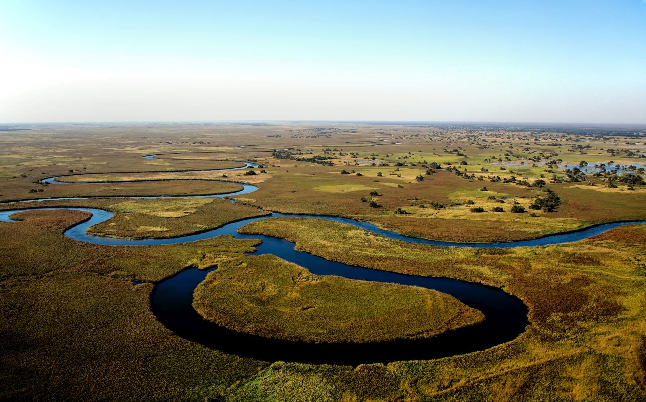
The Okavango River rises in the highlands of Angola, flows 1,600 kilometers southeast through Namibia's Caprivi Strip, and crosses into Botswana near Mohembo village. There it fans across a tectonic trough, spreading into thousands of channels, lagoons, and seasonal floodplains that never reach the sea. Where the Okavango Delta sits today was once part of a vast super-lake; tectonic shifts rerouted its drainage, and the water now evaporates or seeps into the sand, leaving minerals that nourish palm islands and floodplain grasslands. Maun serves as the logistical anchor. Charter flights depart from Maun International Airport to gravel airstrips inside concessions and national park zones, each strip identified by a three-letter code and GPS waypoint rather than a street address. Road access exists along the delta's southern and eastern fringes, where the Matlapana Bridge and Boro River crossings link Maun to safari lodges in the Moremi Game Reserve. The delta's core remains roadless; permanent water channels like the Boro, Santantadibe, and Jao rivers define lodge territories, and mokoro polers navigate by reed-bed landmarks and hippo paths. The delta's geography shifts with the flood cycle. Floodwaters peak between June and August—paradoxically during Botswana's dry winter—because the seasonal rains in Angola take three months to travel the length of the river system. Chiefs Island, the largest landmass within the delta, stays above the flood, while lower floodplains transform from dust to open water. Understanding where the Okavango Delta is located requires grasping its dual nature: a fixed point on the map and a moving body of water that redraws the landscape twice a year. The political address—North-West District, Botswana—places the delta within the traditional lands of the Bayei and Hambukushu peoples, though national park designations and private concessions now govern most of the territory. Latitude and longitude fix its position, but seasonal inundation, not surveyors' lines, determines where the delta begins and the desert resumes. The Okavango Delta location remains one of the most hydrologically dynamic places on the African continent, a wetland with no outlet sustained entirely by a river that refuses to find the ocean.
“The Okavango River travels 1,600 kilometers only to vanish into the Kalahari, creating a wetland with no outlet and no coastline.”
Where Is the Okavango Delta Located and How Do You Get There?
The Okavango Delta is located in the North-West District of Botswana. Most visitors reach this region by flying into Maun, which serves as the primary gateway to the delta.
Mokoro transit from Maun or nearby camps
4x4 transfers from Maun via A3 highway
Light aircraft transfer from Maun International Airport
Optimal Timing for When and Where Is the Okavango Delta Best Visited
The Okavango Delta is best visited between June and August when floodwaters arrive and wildlife congregates near water sources. Daily arrivals are restricted to the 06:00–17:00 window to ensure safe observation during cooler dawn and dusk hours.
Flood Season (June–August)
Moderate to highDry, mild days (15°C–25°C)
Water levels peak, providing ideal conditions for mokoro excursions and wildlife viewing.
Shoulder Season (September–October)
LowHot, dry days (20°C–35°C)
Wildlife gathers at remaining water holes, increasing visibility before the rains arrive.
Green Season (November–April)
LowWarm, humid with rains (20°C–30°C)
Landscape turns lush and migratory birds return, though heavy rains can impact some access.
Daily Arrival Window
——
All visitors must arrive between 06:00–17:00 to align with 4x4 game drive schedules.
Verdict: For optimal wildlife viewing and water access, target the period from June to August, adhering strictly to the 06:00–17:00 daily arrival window.
Operational Hours for Where Is the Okavango Delta Activities
The Okavango Delta region remains accessible throughout the week, though practical navigation depends on daylight conditions. While the area is open to visitors daily, logistical movements are typically confined to specific hours for safety and wildlife management.
| Monday | 00:00–23:59 | |
|---|---|---|
| Tuesday | 00:00–23:59 | |
| Wednesday | 00:00–23:59 | |
| Thursday | 00:00–23:59 | |
| Friday | 00:00–23:59 | |
| Saturday | 00:00–23:59 | |
| Sunday | 00:00–23:59 |
Essential Prep for Where Is the Okavango Delta
Remote location and health requirements demand advance preparation.
-
Book lodge or camp accommodation — Bush strips require confirmed reservations weeks ahead.
-
Arrange charter flights or mobile safari transfers — Road access is limited; most lodges are fly-in only.
-
Obtain comprehensive travel insurance with medical evacuation — Nearest hospitals are hours away by air.
-
Consult a travel clinic for malaria prophylaxis — The delta is a year-round malaria zone.
-
Pack insect repellent and long sleeves — Mosquito activity peaks at dawn and dusk.
-
Confirm passport validity exceeds six months — Botswana immigration enforces strict expiry rules.
-
Carry printed booking confirmations and vouchers — Cellular coverage is sparse across the delta.
Check availability
Frequently Asked Questions About Okavango Delta Location
Everything you need to know about where is the okavango delta